
Positioning without GPS signal? No problem Thales Sophie with VisioLoc is there
Ukraine has shown that relying on GPS might be definitely the wrong choice, Russian jamming disrupting satellite signals. For soldiers who were trained for years in using GPS-based systems it must be quite frustrating to lose this capacity when it is really needed. Calling in fire without knowing your own position as well as that of the target becomes impossible.
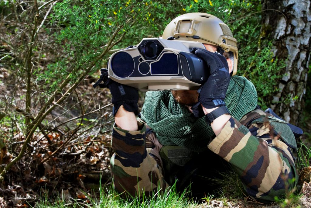
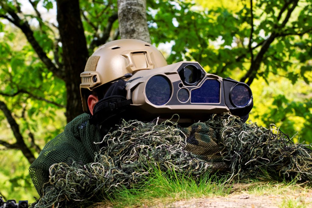
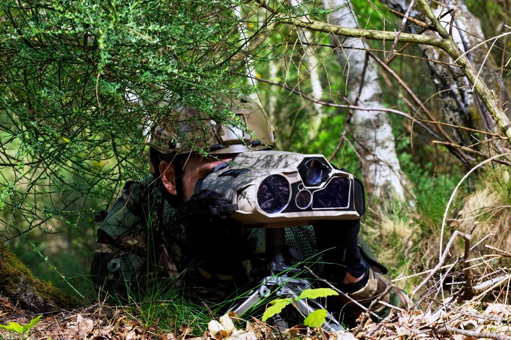
To overcome this problem Thales developed a new capability, and added it to the two latest multifunctional thermal imagers, Sophie Ultima and Sophie Optima, which were unveiled respectively at Eurosatory 2018 and in June 2020. Both manportable systems have a weight under 2.5 kg and include a direct view optical channel with a x7 magnification, a day TV channel, a laser rangefinder (LRF) capable to measure up to 25 km distance, a GPS, and a thermal imager for night vision and for decamouflaging targets also at day. The latter is the sensor making the difference between the two systems, the Ultima being fitted with a Medium Wavelength (3-5 µm) cooled IR sensor with a 15 µm pitch allowing tank recognition at 6 km distance, while the Optima has an uncooled microbolometer working in the Long Wave IR band (8-12 µm), allowing tank recognition up to 3 km. While the Ultima is usually a tool for specialists or Special Forces, the Optima is dedicate to platoon leaders.
The production of the Sophie Ultima has recently started, EDR On-Line witnessing the manufacturing of the low rate initial production items on a U-shaped assembly line, during a visit to the Saint-Héand Thales facility, some 70 km west of Lyon, two weeks prior to Eurosatory. As its uncooled sister, the Ultima housing is not anymore made of metal, as previous Sophie, but in a high-tech composite materiel with a very thin metal coating. Moreover it is not anymore made of two shells coupled once the assembly is finished, but of a single body open to the rear in which the various elements are inserted using a COBOT [1]. Following the assembly, test and calibrating is one of the most time-consuming manufacturing phases. According to the production responsible, now that production has started, albeit not yet at full rate, the learning curve is slowly starting to kick in. “We are planning to start delivering the Ultima in late 2022,” Marie-Solange Milleron, Land & Naval Business Segment Director at ThalesOptonics and Missile Electronics said, adding that “the Optima is still in the last development phase, some 5-10 prototypes having been produced, and first deliveries are forecasted in late 2023-early 2024.”
Now customers choosing one of the 4th Generation Sophie have the option to add to those already complete target acquisition systems a new functionality which was unveiled at Eurosatory, the VisioLoc®.
From the name we can deduce what it is all about, vision and localisation. The two latest Sophie iterations can be loaded with a 0.5 meters resolution Geographic Information System covering 200×200 km contained in a Micro-SD card, “but in 5 years time this will increase to 500×500 km. Looking at the map,” Pierre-Yves Guinet, Product Line Manager at Thales Soldier’s Optronics says. The map can be easily seen onto a ruggedised tablet computer, linked to the Sophie either via Wi-Fi or by cable, and it is possible to pick up three notable features on the ground, from bell towers to trees to water tanks, that are in sight; two features would suffice, however the third allows to highlight potential errors and increases accuracy. The operator picks up the first point with his Sophie, laser it to get the distance, and then must correlate it with the map. The field of view used and the distance allow to easily bring the point on the map, which gives the grids of the first point, a virtual circle with its radius equal to the distance measured with the LRF being drawn. The operation is repeated for the two other features, and the interception of the three circles gives the operator’s position. Having the coordinates of the other three points and the distances, it is now just a matter of calculation. Overall, it takes around three minutes to complete the procedure.
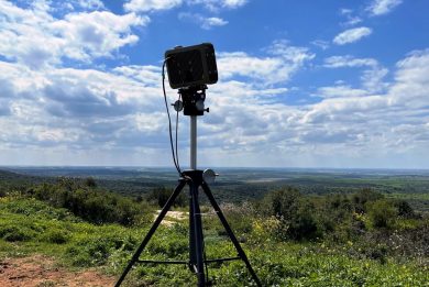
EDR On-Line could witness a demonstration of the VisioLoc during the aforementioned visit to Saint-Héand, the Thales Group’s centre of excellence for soldier optronics, which has a workforce of around 350 people and deals not only with defence optronics but is also the home of te famous Angénieux zoom lenses uses by most high-end movie producers. Taking up three features between 1.5 and 3 km distance, one of which a tree that was visible between two other trees so some discrimination in distance was needed to confirm the measure, and verifying the accuracy with that provided by the Sophie GPS with 15 satellites in view, results were pretty similar, the CEP being less than 6 meters with the Sophie mounted on a light tripod.
Once the position of the Sophie is known, it is then possible to get that of a target with utmost accuracy. Introducing a high resolution panoramic digitised image, and knowing the reference points positions, allows obtaining a digitised scenario in which each pixel is de-facto referenced, the angle accuracy being under 1 milliradiant, much less than what can be done with a magnetic north seeker which accuracy is of 1°, equivalent to 17 milliradiants; in the end the CEP of a target would increase from the 6 meters obtained with the VisioLoc to around 100 meters, according to Thales experts. We must however say that non-magnetic north finding systems also exist.
Taking as example a French Army platoon equipped with Scorpion equipment, therefore trained at conducing collaborative combat, not knowing the respective positions would impede the latter. If the platoon commander is equipped with the Sophie Ultima he can definitely get its other vehicles exact positions, allowing the SIC-S to go back to collaborative engagement, at least until these do not start back to move. The same applies to a JTAC who needs to send a nine-liner or to a FOO who needs to send a call-for-fire. Not to forget that most vehicles are fitted with GPS/INS navigation platforms; this allows them to exploit the Inertial Navigation System when the GPS is unavailable, however the INS tends to drift and a position upgrade is needed by time to time; the Sophie Ultima and Optima can definitely be used in this role.
When designing the Sophie Ultima and Optima, Thales considered since inception the growth potential needed for new applications, hence the computing power available on board the two systems is well sufficient to support the VisioLoc, a computing heavy application, some more remaining for further additions. As a term of comparison EDR On-Line was told that the VisioLoc was installed on a previous generation Sophie; the computing time for getting the coordinates took around 24 hours, compared to the 40 seconds when using the Ultima. “Another beneficial aspect is weight reduction in the soldiers’ rucksack, as they will not have to carry the north finding head on which the target acquisition binocular will be mounted, the Ultima and Optima already allowing a considerable saving as they pack four functions into a single instrument, while in the past soldiers had to carry a number of separate items to cover the same capacities,” Pascal Sécretin, Thales Imagers and Sensors product line director and a former HALO/HAHO qualified military paratrooper states.
As seen, the most critical operation is probably the correlation between the feature seen through the Sophie and that on the map. The human machine interface purposely developed by Thales allowed however a trained operator to do it in less than 30 seconds, as seen during the demonstration. Asked about possible solution provided by Artificial Intelligence-based algorithms, Thales experts underlined the difficulty of matching an image taken from a sensor at the same level with that taken from a sensor in the sky, so a top-view. Any AI add-on would need the addition of a neural network element to the system, which must be integrated as close as possible to avoid huge latency times. The Sophie has on its left side a slot where further capabilities can be added, one often mentioned being a Short-Wave IR sensor another being 5G connection. Integrating there the aforementioned neural system might be feasible, however the other element to be considered is power consumption, as such an add-on would be quite power hungry, around 5 W, therefore dramatically decreasing the system autonomy. Will such a capability ever materialise on current hand-held targeting systems remain questionable.
However some more capabilities, that can exploit the
computing power availability that still remains on the Sophie Ultima and Optima
might well appear in the coming years, as the development roadmap has
definitely not yet reached the end.
Photos courtesy Thales
[1] COBOT is the acronym of collaborative robot, and is an artificially intelligent robot that performs tasks in collaboration with human workers.